United States
£ GBP
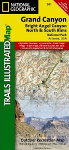
Grand Canyon, Bright Angel Canyon/North & South Rims (#261) replaces the previous Grand Canyon National Park Trails Illustrated map (#207). Completely redesigned and updated, Grand Canyon Central provides an enhanced scale and detail for the highest visitation area of the park surrounding the Grand Canyon South Rim Visitor Center and the Bright Angel Trail. (Colorado River miles 60-98).
Designed with a wide range of visitors in mind, Grand Canyon Central features detailed and easy to read trails, accurate road network, campgrounds, scenic overlooks and points of interests, visitor centers and facilities, color coded bus stops with routes, plus park regulations, backcountry use areas, and contact information for local agencies. This well-balanced mix of detailed cartography and handy resource information makes all Trails Illustrated maps an invaluable resource for both planning and exploring the park. This map features an enhanced scale (35K) for increased detail in this high-use area of Grand Canyon National Park.
Features Included:
Colorado River miles 60-98, North and South Rim visitor centers, Grand Canyon Village, Grand Canyon / National Geographic IMAX, Tusayan, Grand Canyon Railroad Station, Bright Angel Trail (plus elevation profile), West Rim Trail, Kaibab Trail, Arizona Trail, Grand Canyon Lodge, and more.
Approximately 4.25" x 9.25" folded; 26" x 38" fully opened
Scale = 1:35,000


![Costa Rica Wildlife Guide: Mammals, Birds, Reptiles, Amphibians, Butterflies [English / Spanish]](http://mediacdn.nhbs.com/jackets/jackets_resizer_medium/19/196493.jpg?height=150&width=65)


