United States
£ GBP
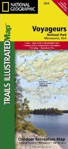
Located at the border of Minnesota and Canada, Voyageurs National Park is frequented by over ¼ million visitors each year. Defined by its interconnected waterways, the park requires you to leave your car behind and explore the Northwood Lake Country by kayak, canoe, houseboat, or motorboat.
Our new Trails Illustrated map for Voyageurs National Park was developed in cooperation with local land managers, ensuring that it is the most accurate and up-to-date available. Like all Trails Illustrated Maps, Voyageurs is printed in the USA on waterproof, tear-resistant, material — a necessity for the water based activities in the park.
Our Voyageurs map contains detailed park information for all seasons, including hiking trails, campgrounds, portages, snowshoe trails, snowmobiling trails, trail access points, detailed roads, park services, plus opportunities for boating, fishing, kayaking, power boating, and more.
The Voyageurs NP Trails Illustrated map is being release in tandem with two new maps for Minnesota’s Boundary Waters Canoe Area / Superior National Forest.
Coverage Highlights
Areas and places featured in this map include:
• Park Attractions: Gull Island Rookery, Grassy Bay Cliffs, Anderson Bay, Kettle Falls, Hoist Bay, Gold Portage
• Ash River, Crane Lake, Kabetogama and Rainy Lake Visitor Centers
Approximately 4.25" x 9.25" folded; 26" x 38" fully opened
Scale = 1:70,000 (1” = 1.10 miles)


![Costa Rica Wildlife Guide: Mammals, Birds, Reptiles, Amphibians, Butterflies [English / Spanish]](http://mediacdn.nhbs.com/jackets/jackets_resizer_medium/19/196493.jpg?height=150&width=65)


