United States
£ GBP
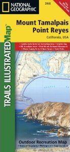
National Geographic's Trails Illustrated map of Point Reyes and Mount Tamalpais is a two-sided, waterproof map designed to meet the needs of outdoor enthusiasts with unmatched durability and detail. This map was created in conjunction with local land management agencies and is loaded with valuable recreation information. The front side of the map details Point Reyes National Seashore and the northern portion of Golden Gate National Recreation Area. On the reverse side of the map Mount Tamalpais Park is featured, as well as the southern portion of Golden Gate National Recreation Area, Angel Island State Park and the city of San Rafael.
The Point Reyes and Mount Tamalpais map is printed in the United States on durable synthetic paper, making it waterproof, tear-resistant, and trail tough — capable of going anywhere you do.
Approximately 4 1/4" x 9 1/4" folded; 26" x 38" fully opened
Scale = 1:45,000


![Costa Rica Wildlife Guide: Mammals, Birds, Reptiles, Amphibians, Butterflies [English / Spanish]](http://mediacdn.nhbs.com/jackets/jackets_resizer_medium/19/196493.jpg?height=150&width=65)


