United States
£ GBP
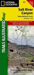
One of the most-visited urban forests in the U.S., with approximately 5.8 million visitors annually, the Tonto National Forest spans almost 3 million acres of diverse terrain just outside of Phoenix, AZ. Tonto encompasses a wide variety of vegetation ranging from cactus-studded desert to pine-forested mountains, and numerous recreational opportunities throughout the year.
Our four new Trails Illustrated maps are the most detailed and up-to-date for the forest, carefully researched and developed in co-operation with local land managers and agencies. Each map contains easy to read trails, numbered forest service roads, campsites, access points, scenic points-of-interest, and important facilities.
Like all Trails Illustrated maps our new Tonto National Forest titles are both highly durable and environmentally friendly. Each map is printed in the United States, at a certified green printer, using low V.O.C. inks on waterproof, tear-resistant material. Proceeds from the sale of Tonto National Forest Trails Illustrated Maps go to support the National Geographic Society’s nonprofit mission to increase global understanding and promote conservation of our planet through exploration, research, and education.
Coverage includes
- Salt River Canyon & White Canyon Wilderness Areas
- Arizona Trail
- Gila-Pinal & Desert to the Pines Scenic Byways
- Gila River
- Locations of Public Facilities and Fee Areas
- Motorized and Non-Motorized Trails
- Equestrian & Multiple Use Trails
- Globe, Mesa and Tonto Basin Ranger Districts
- Agency Contact and Recreation Information
Approximately 4.25" x 9.25" folded; 26" x 38" fully opened
Scale = 1:70,000


![Costa Rica Wildlife Guide: Mammals, Birds, Reptiles, Amphibians, Butterflies [English / Spanish]](http://mediacdn.nhbs.com/jackets/jackets_resizer_medium/19/196493.jpg?height=150&width=65)


