United States
£ GBP
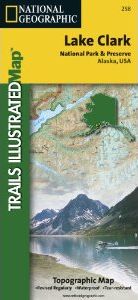
This two-sided map includes Lake Clark National Park and Preserve in its entirety, McNeil River State Game Refuge, Tuxedni Wilderness, as well as portions of Katmai National Preserve. The map includes the towns of Port Alsworth, Iniskin, Dutton, Old Iliamna, Pile Bay Village, Pedro Bay, Chekok, Iliamna, Newhalen, Kokhanok, Chinitna Bay, Chenik, and Drift River. Natural features include Lake Clark, Iliamna Lake Cook Inlet, Kamishak Bay, Ursus Cove, Augustine Island, Telaquana Lake, Twin LAkes, Turquoise Lake, Chakachamna Lake, the Neacola Mountains, Chigmit Mountains, Aleutian Range, and much more. The second side of the map features a large scale map of portions of Lake Clark National Park and Preserve, including Telaquana Lake Turquoise Lake, Twin Lakes, Snipe Lake, Tanalian Mountain, Tanalian Falls Trail, Copper Mountain, Kontrashibuna Lake, Currant Creek, and historic native routes through the area. The map includes historical information about the park, information on trip planning, permits, backpacking, float trips / rafting, hunting and fishing, phone numbers for more information, and backcountry safety tips. Includes UTM tick marks for use with your GPS unit.
Approximately 4.25" x 9.25" folded; 26" x 38" fully opened
Scale = 1:350,000 & 1:135,000


![Costa Rica Wildlife Guide: Mammals, Birds, Reptiles, Amphibians, Butterflies [English / Spanish]](http://mediacdn.nhbs.com/jackets/jackets_resizer_medium/19/196493.jpg?height=150&width=65)


