To see accurate pricing, please choose your delivery country.
 
 
United States
£ GBP
All Shops

British Wildlife

8 issues per year 84 pages per issue Subscription only

British Wildlife is the leading natural history magazine in the UK, providing essential reading for both enthusiast and professional naturalists and wildlife conservationists. Published eight times a year, British Wildlife bridges the gap between popular writing and scientific literature through a combination of long-form articles, regular columns and reports, book reviews and letters.

Subscriptions from £33 per year

Conservation Land Management

4 issues per year 44 pages per issue Subscription only

Conservation Land Management (CLM) is a quarterly magazine that is widely regarded as essential reading for all who are involved in land management for nature conservation, across the British Isles. CLM includes long-form articles, events listings, publication reviews, new product information and updates, reports of conferences and letters.

Subscriptions from £26 per year
Academic & Professional Books  Natural History  Regional Natural History  Natural History of the Americas

Puerto Rico & Virgin Islands: Map for Virgin Islands National Park Trails Illustrated National Parks

Series: Trails Illustrated Maps Volume: 236
By: National Geographic(Author)
1 pages, illustrations
Puerto Rico & Virgin Islands: Map for Virgin Islands National Park
Click to have a closer look
  • Puerto Rico & Virgin Islands: Map for Virgin Islands National Park Not in stock: Usually dispatched within 2-3 weeks
    £8.99
    #202160
Price: £8.99
About this product Customer reviews Related products

About this product

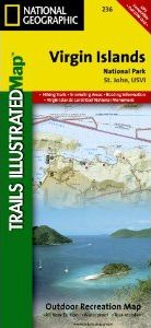
This Trails Illustrated topographic map for Virgin Islands National Park, and surrounding area on the island of St. John, US Virgin Islands. The map includes the island of St. John, Virgin Islands National Park in its entirety, Virgin Islands Coral Reef National Monument, Mount Sage national Park, Tortola Island, Great Thatch Island, Little Thatch Island, Frenchmans Cay, End, Lovango Cay, Congo Cay, Mingo Cay, Dog Island, Hawksnest Bay, Durloe Cays, Durloe Channel, Cinnamon Bay, Trunk Bay, Mary Point, Francis Bay, and much more. Includes UTM grids for use with your GPS unit.

Approximately 4.25" x 9.25" folded; 26" x 38" fully opened
Scale = 1:22,000

Customer Reviews

Series: Trails Illustrated Maps Volume: 236
By: National Geographic(Author)
1 pages, illustrations
Current promotions
New and Forthcoming BooksNHBS Moth TrapBritish Wildlife MagazineBuyers Guides