To see accurate pricing, please choose your delivery country.
 
 
United States
£ GBP
All Shops

British Wildlife

8 issues per year 84 pages per issue Subscription only

British Wildlife is the leading natural history magazine in the UK, providing essential reading for both enthusiast and professional naturalists and wildlife conservationists. Published eight times a year, British Wildlife bridges the gap between popular writing and scientific literature through a combination of long-form articles, regular columns and reports, book reviews and letters.

Subscriptions from £33 per year

Conservation Land Management

4 issues per year 44 pages per issue Subscription only

Conservation Land Management (CLM) is a quarterly magazine that is widely regarded as essential reading for all who are involved in land management for nature conservation, across the British Isles. CLM includes long-form articles, events listings, publication reviews, new product information and updates, reports of conferences and letters.

Subscriptions from £26 per year
Academic & Professional Books  Natural History  Regional Natural History  Natural History of the Americas

South Dakota: Map for Black Hills-Northeast NF

Series: Trails Illustrated Maps Volume: 751
By: National Geographic
Scale: 53Th
South Dakota: Map for Black Hills-Northeast NF
Click to have a closer look
  • South Dakota: Map for Black Hills-Northeast NF Not in stock: Usually dispatched within 2-3 weeks
    £8.99
    #81613
Price: £8.99
About this product Customer reviews Related products

About this product

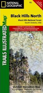
This detailed Trails Illustrated topographic map for the northern region of South Dakota's Black Hills National Forest and the surrounding area is the ideal map for exploring the outstanding scenery and numerous trails for hiking, mountain biking, horseback riding, snowmobiling and cross-country skiing. 

Users will find clearly marked trails, updated roads, protected areas, ranger stations, visitor centers, picnic areas, campsites, ski locations, swimming and fishing areas and boat launches. 

Popular Places Included on the Map
Black Hills National Forest, Fort Meade Recreation Area, Spearfish Canyon Scenic Byway, Deerfield Lake, Pactola Reservoir, Sheridan Lake and the George S. Mickelson and Centennial Trails. 

Key Features
- Waterproof and tear-resistant
- Hundreds of points-of-interest
- Thousands of place names
- Latitude/Longitude, UTM, and Magnetic Declination - for use with GPS and compass
- Travel and key contact information for Black Hills National Forest and Fort Meade Recreation Area
- Leave No Trace outdoor ethics guidelines
- Key safety information 

Approximately 4.25" x 9.25" folded; 26" x 38" fully opened 
Scale = 1:70,000

Customer Reviews

Series: Trails Illustrated Maps Volume: 751
By: National Geographic
Scale: 53Th
Current promotions
New and Forthcoming BooksNHBS Moth TrapBritish Wildlife MagazineBuyers Guides