To see accurate pricing, please choose your delivery country.
 
 
United States
£ GBP
All Shops

British Wildlife

8 issues per year 84 pages per issue Subscription only

British Wildlife is the leading natural history magazine in the UK, providing essential reading for both enthusiast and professional naturalists and wildlife conservationists. Published eight times a year, British Wildlife bridges the gap between popular writing and scientific literature through a combination of long-form articles, regular columns and reports, book reviews and letters.

Subscriptions from £33 per year

Conservation Land Management

4 issues per year 44 pages per issue Subscription only

Conservation Land Management (CLM) is a quarterly magazine that is widely regarded as essential reading for all who are involved in land management for nature conservation, across the British Isles. CLM includes long-form articles, events listings, publication reviews, new product information and updates, reports of conferences and letters.

Subscriptions from £26 per year
Academic & Professional Books  Natural History  Regional Natural History  Natural History of the Americas

Utah: Map for Zion National Park

Series: Trails Illustrated Maps Volume: 214
By: National Geographic(Author)
Scale: 1:37,700
Utah: Map for Zion National Park
Click to have a closer look
  • Utah: Map for Zion National Park Not in stock: Usually dispatched within 2-3 weeks
    £8.99
    #81624
Price: £8.99
About this product Customer reviews Related products

About this product

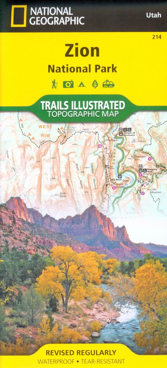
Covering all of Zion National Park, our Trails Illustrated map contains detailed topography with shaded relief, up-to-date trails, roads, and points of interest, plus trail summaries and useful information to get the most from your visit. 

The North side of the map covers the popular Zion Narrows with a companion hiking timetable, plus Kolob Canyons, La Verkin Creek Trail, Hop Valley Trail, Wildcat Canyon, the West Rim Trail, and more. The South side of the map details the park headquarters, Floor of the Valley Road, East Rim Trail, Telephone Canyon Trail, and the Virgin River. 

Printed on durable, waterproof, tear-resistant and environmentally friendly material that will stand up to any outdoor condition. Both sides feature a UTM and Latitude/Longitude grid for use with a GPS, plus compass rose, scale bar and legend for easy interpretation.

Approximately 4.25" × 9.25" folded; 26" × 38" fully opened
Scale = 1:37,700

Customer Reviews

Series: Trails Illustrated Maps Volume: 214
By: National Geographic(Author)
Scale: 1:37,700
Current promotions
New and Forthcoming BooksNHBS Moth TrapBritish Wildlife MagazineBuyers Guides