To see accurate pricing, please choose your delivery country.
 
 
United States
£ GBP
All Shops

British Wildlife

8 issues per year 84 pages per issue Subscription only

British Wildlife is the leading natural history magazine in the UK, providing essential reading for both enthusiast and professional naturalists and wildlife conservationists. Published eight times a year, British Wildlife bridges the gap between popular writing and scientific literature through a combination of long-form articles, regular columns and reports, book reviews and letters.

Subscriptions from £33 per year

Conservation Land Management

4 issues per year 44 pages per issue Subscription only

Conservation Land Management (CLM) is a quarterly magazine that is widely regarded as essential reading for all who are involved in land management for nature conservation, across the British Isles. CLM includes long-form articles, events listings, publication reviews, new product information and updates, reports of conferences and letters.

Subscriptions from £26 per year
Academic & Professional Books  Natural History  Regional Natural History  Natural History of the Americas

Utah: Map for Glen Canyon/Lake Powell/Capitol Reef

Series: Trails Illustrated Maps Volume: 213
By: National Geographic
Scale: 177.3Th
Utah: Map for Glen Canyon/Lake Powell/Capitol Reef
Click to have a closer look
  • Utah: Map for Glen Canyon/Lake Powell/Capitol Reef Not in stock: Usually dispatched within 2-3 weeks
    £8.99
    #81623
Price: £8.99
About this product Customer reviews Related products

About this product


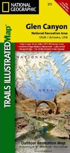
Our Glen Canyon NRA and Rainbow Bridge NM Trails Illustrated map provides detailed topographic coverage, trails, and locations of important recreational points of interest for outdoor enthusiasts. Inset maps for Hite, Halls Crossing, Dangling Rope, Bullfrog Bay, and Wahweap marinas and campgrounds show the location of key facilities such as boat ramps, RV campgrounds, laundry facilities, and parking.

Like all Trails Illustrated maps, our Glen Canyon title is printed on durable, waterproof, tear-resistant material that will stand up to the elements. Selected locations on the map are shown with GPS waypoints for use with handheld GPS receivers. 

Approximately 4.25" x 9.25" folded; 26" x 38" fully opened
Scale = 1:90,000

Customer Reviews

Series: Trails Illustrated Maps Volume: 213
By: National Geographic
Scale: 177.3Th
Current promotions
New and Forthcoming BooksNHBS Moth TrapBritish Wildlife MagazineBuyers Guides