To see accurate pricing, please choose your delivery country.
 
 
United States
£ GBP
All Shops

British Wildlife

8 issues per year 84 pages per issue Subscription only

British Wildlife is the leading natural history magazine in the UK, providing essential reading for both enthusiast and professional naturalists and wildlife conservationists. Published eight times a year, British Wildlife bridges the gap between popular writing and scientific literature through a combination of long-form articles, regular columns and reports, book reviews and letters.

Subscriptions from £33 per year

Conservation Land Management

4 issues per year 44 pages per issue Subscription only

Conservation Land Management (CLM) is a quarterly magazine that is widely regarded as essential reading for all who are involved in land management for nature conservation, across the British Isles. CLM includes long-form articles, events listings, publication reviews, new product information and updates, reports of conferences and letters.

Subscriptions from £26 per year
Academic & Professional Books  Natural History  Regional Natural History  Natural History of the Americas

Utah: Map for Moab North Trails Illustrated Other Rec. Areas

Series: Trails Illustrated Maps Volume: 500
1 pages, illustrations
Utah: Map for Moab North
Click to have a closer look
  • Utah: Map for Moab North Not in stock: Usually dispatched within 2-3 weeks
    £8.99
    #202063
Price: £8.99
About this product Customer reviews Related products

About this product


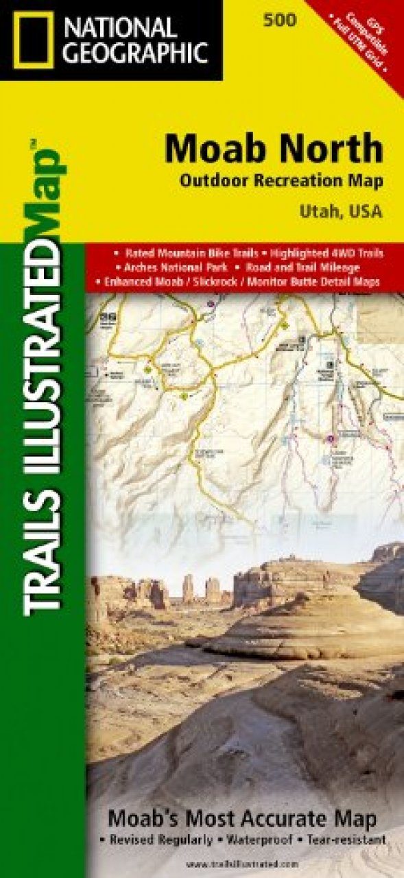
This detailed recreation map contains carefully researched trails, campsites, BLM roads, The Colorado River Way area and Colorado River mileages, Green River mileages, Fisher Towers, and points-of-interests. Detailed Trail Charts describing the Mountain Bike and Jeep Trails are included. These charts include mileages and difficulty ratings to better help you plan your trip. Also included is information on Mountain Biking and Desert Safety. Useful UTM and Latitude/Longitude grids are included to help you locate yourself in the backcountry. State and Private lands are also shown.

Moab North: Includes Arches National Park, the Kokopelli Trail, and portions of the Manti-La Sal National Forest. This map includes overlap with TI-703 (Manti La Sal National Forest). In addition, this map will also overlap with TI-208 (Colorado National Monument).

Moab North Back: Includes highly detailed insets and enhanced coverage for Moab's most popular Mountain Biking and Jeep Route areas. These insets include; Monitor & Merrimac Buttes, Bartlett Wash, the Sovereign Trail, the town of Moab, Slickrock and Porcupine Rim, Green River and Ten Mile Point.

Approximately 4.25" x 9.25" folded; 26" x 38" fully opened 
Scale = 1:70,000 & 1:35,000

Customer Reviews

Series: Trails Illustrated Maps Volume: 500
1 pages, illustrations
Current promotions
New and Forthcoming BooksNHBS Moth TrapBritish Wildlife MagazineBuyers Guides