To see accurate pricing, please choose your delivery country.
 
 
United States
£ GBP
All Shops

British Wildlife

8 issues per year 84 pages per issue Subscription only

British Wildlife is the leading natural history magazine in the UK, providing essential reading for both enthusiast and professional naturalists and wildlife conservationists. Published eight times a year, British Wildlife bridges the gap between popular writing and scientific literature through a combination of long-form articles, regular columns and reports, book reviews and letters.

Subscriptions from £33 per year

Conservation Land Management

4 issues per year 44 pages per issue Subscription only

Conservation Land Management (CLM) is a quarterly magazine that is widely regarded as essential reading for all who are involved in land management for nature conservation, across the British Isles. CLM includes long-form articles, events listings, publication reviews, new product information and updates, reports of conferences and letters.

Subscriptions from £26 per year
Academic & Professional Books  Natural History  Regional Natural History  Natural History of the Americas

Virginia: Map for Lexington/Blue Ridge, G.W. & Jefferson National Forests Trails Illustrated Other Rec. Areas

Series: Trails Illustrated Maps Volume: 789
By: National Geographic(Author)
1 pages, illustrations
Virginia: Map for Lexington/Blue Ridge, G.W. & Jefferson National Forests
Click to have a closer look
  • Virginia: Map for Lexington/Blue Ridge, G.W. & Jefferson National Forests Not in stock: Usually dispatched within 2-3 weeks
    £8.99
    #202148
Price: £8.99
About this product Customer reviews Related products

About this product

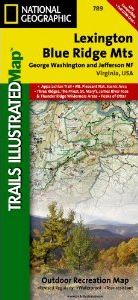
Coverage includes George Washington and Jefferson National Forest. Towns: Lexington, Buena Vista, Waynesboro, Bedford, Blue Ridge. Wilderness Areas: The Priest, Three Ridges, Saint Mary's, Thunder Ridge, James River Face. Major Trails: Appalachian National Scenic Trail, Glenwood Horse Trail. Other Highlights: Blue Ridge Parkway, Peaks of Otter, Mount Pleasant National Scenic Area. Includes UTM grids for use with your GPS unit and a trail mileage matrix.

Approximately 4.25" x 9.25" folded; 26" x 38" fully opened
Scale = 1:75,000

Customer Reviews

Series: Trails Illustrated Maps Volume: 789
By: National Geographic(Author)
1 pages, illustrations
Current promotions
New and Forthcoming BooksNHBS Moth TrapBritish Wildlife MagazineBuyers Guides