About this book
For many, a map is nothing more than a tool used to determine the location or distribution of something – a country, a city, or a natural resource. But maps reveal much more: to really read a map means to examine what it shows and what it doesn't, and to ask who made it, why, and for whom. The contributors to this new volume ask these sorts of questions about maps of Latin America, and in doing so illuminate the ways cartography has helped to shape this region from the Rio Grande to Patagonia.
In Mapping Latin America,Jordana Dym and Karl Offen bring together scholars from a wide range of disciplines to examine and interpret more than five centuries of Latin American maps.Individual chapters take on maps of every size and scale and from a wide variety of mapmakers – from the hand-drawn maps of Native Americans, to those by famed explorers such as Alexander von Humboldt, to those produced in today's newspapers and magazines for the general public. The maps collected here, and the interpretations that accompany them, provide an excellent source to help readers better understand how Latin American countries, regions, provinces, and municipalities came to be defined, measured, organized, occupied, settled, disputed, and understood – that is, how they came to have specific meanings to specific people at specific moments in time.
The first book to deal with the broad sweep of mapping activities across Latin America, this lavishly illustrated volume will be required reading for students and scholars of geography and Latin American history, and anyone interested in understanding the significance of maps in human cultures and societies.
Contents
Foreword Matthew H. Edney
Acknowledgments
Introduction Karl Offen and Jordana Dym
I. The Colonial Period: Explorations and Empires
Imagining a New World
1. Early Empires Francisco Estrada-Belli and Heather Hurst
Mural, north wall of Room 1 at La Sufricaya, Guatemala, ca. AD 379
2. America John Hébert
Martin Waldseemüller, Universalis cosmographia, 1507
3. Charting Shores Ricardo Padrón
Diogo Ribeiro, CartaUniversal , 1529
4. Fabled Land D. Graham Burnett
Walter Ralegh, map of Guiana (El Dorado), ca. 1596
Urban Society
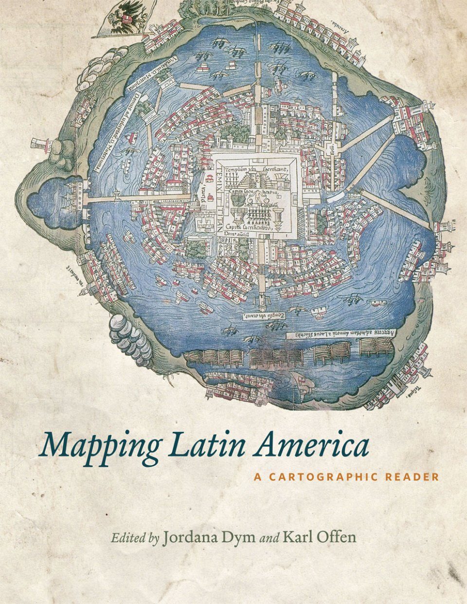
5. Indigenous Civilization Barbara E. Mundy
Map of Tenochtitlán (Mexico), 1524
6. Projecting Order Richard L. Kagan
Plano fundacional de San Juan de la Frontera (Argentina), 1571
Plaza Mayor de Lima , 1680
7. Hybrid Space Barbara E. Mundy
Map from the Relación Geográfica of Cholula (Mexico) , 1579–1581
Environment and Society
8. Litigating Land Barbara E. Mundy
Oztoticpac Lands Map, Texcoco (Mexico), ca. 1540
9. Mining Mountains Peter Bakewell
Illustration with map of a Potosí silver refining mill and Cerro Rico, ca. 1590
Planta general de la Villa Ymperial de Potosí (Bolivia), ca. 1590
10. Between Two Seas W. George Lovell and Christopher H. Lutz
Antonio Herrera, Descripción del Avdiencia de Gvatimala, 1604
Juan López de Velasco, Descripción de la Audiencia de Guatemala, 1575
11. Bourbons and Water Vera S. Candiani
Joaquín Velázquez de León and Joseph de Burgaleta , Perfil y corte por la latitud de las compuertas y puntos principales del canal de Huehuetoca < (Mexico), 1774
Ignacio Castera, Plano general de toda la extensión del Desagüe < (Mexico), 1795
Counter Visions
12. Andean Empire Rolena Adorno
Felipe Guaman Poma de Ayala, map of Huamanga (Peru), 1590s
Felipe Guaman Poma de Ayala, Mapa mundi de[l] Reino de las In[di]as, 1615
13. Imperial Rivalries Matthew Restall
Herman Moll, A Map of the West-Indies . . . explaining what belongs to Spain, England, France, Holland, etc., 1715
14. Allegory and Empire Ricardo Padrón
Vicente de Memije , Aspecto Simbólico del Mundo Hispánico, 1761
Vicente de Memije , Aspecto Geográphico del Mundo Hispánico , 1761
Control and Defense
15. Edge of Empire Karl Offen
[Sabastián de Aranciuia y Sasi], Mapa de lo principal de la Prouincia de Nicaragua , 1716
Franciso Antonio Fuentes y Guzmán, Audiencia de Guatemala, ca. 1690
16. Mapping New Spain Borderlands Dennis Reinhartz
Agustín López de la Cámara Alta et al., Mapa General . . . de la nueba colonia Santander (Mexico) , 1758
Francisco José de Haro, . . . todas las billas y lugares de españoles haci como las Missiones de indios y presidios existentes en la Provincia Nuevo Santander ( Mexico), ca. 1770
17. Forts and Ports Joseph L. Scarpaci
Antonio M. de la Torre y Cárdenas, Plano de la Plaza de la Havana (Cuba), 1817
Agustín Crame, Plano de la Plaza de Panamá , 1779
18. Estate Maps David Buisseret
[Robert Baugh], Plan of Papine Estate (Jamaica), 1834,
Plan de la première, seconde et troisième habitations de M. de Laborde (Haiti), ca. 1790
Bourbon Space
19. Myths and Measurements Neil Safier
Charles-Marie de la Condamine, Carte du cours du Maragnon (Amazon basin), ca. 1745
20. Creole Landscapes Magali M. Carrera
José Antonio de Alzate Ramírez, Nuevo mapa geográfico de la América septentrional española (Mexico), 1767
Luis de Mena, casta panel (Mexico), ca. 1750
21. Cartographic Independence Junia Ferreira Furtado
José Joaquim da Rocha, Mapa da capitania da Minas Gerais < (Brazil), 1778
José Joaquim da Rocha, Mapa da comarca da Sabará (Brazil), 1778
II. The Nineteenth Century : Enlightenment, Independence, and the Nation-State
Exploration and Cartography
22. Mapping Mountains Karl S. Zimmerer
Alexander von Humboldt and Aimé Bonpland, Géographie des plantes équinoxiales (the Chimborazo Map) ( Ecuador), 1807
Pedro Cieza de León, Brevis exactaq totivs novi orbis < (South America), 1560
23. Traversing Space D. Graham Burnett
John Arrowsmith, Map of Guayana to Illustrate the route of R. H. Schomburgk, 1840
24. Cutting Across Peter H. Dana
Lionel Gisborne, Atlantic and Pacific Junction: Topographical Map of a portion of the Isthmus of Darien In Site Of Proposed Inter-Oceanic Navigation (Panama), 1852
25. Minerals and War Karl Offen
Josiah Harding, Map of Part of the Desertof Atacama(Bolivia), 1877
Bounding the State
26. Initial Boundaries Jordana Dym
[John Arrowsmith], Chart to Accompany Thompson’s Official Visit to Guatemala (Central America), 1829
27. Interior Designs Lina del Castillo
Agustín Codazzi, Mapa Corográfico de la Provincia de Vélez (Colombia), 1850
28. Historical Geographies Raymond B. Craib
Antonio García Cubas, Carta General de la República de México , 1858
Antonio García Cubas, Los Insurgentes: Un juego histórico (Mexico), 1891
29. Drawing the Line Paula Rebert
[Comisión de Límites Mexicana], “No. 29. Línea divisoria entre México y los Estados Unidos,” [1857]
30. Measuring Up and Fitting In Carla Lois
Demócrito, El compás con el que nos mide Europa (Argentina), 1887
Instituto Geográfico Militar, Superficies comparées avec celle de la République Argentine , 1913
Order and Progress
31. Coffee Grounds Stefania Gallini
Herman Aú, Mapa de la República de Guatemala , 1876
32. Portraying and Planning a City Fernando Pérez Oyarzun and José Rosas Vera
Teófilo Mostardi-Fioretti, Plano topográfico de la ciudad de Santiago de Chile , 1864
Ernest Ansart, Plano de Santiago (Chile), 1875
33. From Field to Port Michael Johns
Dirección de Ferrocarriles Nacionales, Mapa de Los Ferrocarriles en Explotación, República Argentina , 1895
34. The Life of a Map Raymond B. Craib
Copy of a map of San Juan Bautista de Acultzingo, Veracruz (Mexico), 1895
Martin Holzinger, Plano de la División de los Terrenos del Pueblo de Acultzingo (Mexico), 1872
III. The Twentieth Century: Maps for Every Purpose and Many New Mapmakers
Imagined Communities
35. Educating the Nation Lina del Castillo
Oficina de Longitudes, Mapa de la República de Colombia dedicado a la instrucción pública , 1920
Ángel M. Díaz Lemos, Carta de Colombia , ca. 192–
36. Reordering Our World Jennifer A. Jolly
Joaquín Torres-García, Inverted Map of South America, 1936
Joaquín Torres-García , Inverted Map of South America, 1943
37. National Production Carla Lois
Control de Estado de la Presidencia de la Nación, ¡Produzcamos! (Argentina), 1950
38. Representing the Nation Sarah A. Radcliffe
Ubicación territorial de los pueblos indígenas del Ecuador , 2005
39. Ties That Bind Marie Price
Ryan Morris, map for the article “The Mexican Connection,” Atlantic Monthly, 2007
Urban Planning
40. A Fruit Company Town John Soluri
Tela Railroad Co., Diesel and Fuel Oil Facilities in Tela (Honduras), 1934
U.S. Marine Corps Intelligence Section, Tela, Honduras, 1929
41. Tropical Modernism Sylvia Ficher and Francisco Leitão
Lucio Costa, Plano Piloto de Brasília, (Brazil), 1957
Lucio Costa, s ketches of the Plano Piloto, 1957
42. On the Road James R. Akerman
General Drafting Co. for Esso Standard Oil, S.A., Mapa de las carreteras de la República de Cuba (© 1956), 1961
43. Mass Transit Alain Musset
Sistema de Transporte Colectivo, Ciudad de México, Red del Metro, Ciudad de México, 2005
44. Open for Business Altha J. Cravey
El Paso Chamber of Commerce, Twin Plants: American Factories on the Mexican Border, 1973
Keller Koch Realtors, Juárez Industrial ParksMap (Mexico), 2007
45. Mayas and Tourism Markets Walter E. Little
Junta Departamental de Turismo de Sacatepéquez , Visite Antigua Guatemala , 1963
Colección Veras, La Antigua Guatemala , 1996
Revolution and Resistance
46. National Security and Transnational Insecurity Michael J. Schroeder
Cuba: The Strategic Location, 1962
U-2 reconnaissance photographs of Cuban missile installations, 1961
47. Revolutionary Power, Divided State Joaquín M. Chávez
FMLN, Mapa oficial de la República de El Salvador, annotated ca. 1991
48. Controlling People and Space Matthew J. Taylor and Michael K. Steinberg
Anonymous witness, Mapa 12: Samaritano (etnomapa) (Guatemala), 1992
49. Sewing Resistance Ericka Kim Verba
Untitled testimonial tapestry of a mother seeking a desaparecido (Chile), ca. 1973–1980s
Untitled testimonial tapestry of a shantytown (Chile), ca. 1970s-1980s
Geography, Environment, and Resources
50. Vertical Environments Karl S. Zimmerer
Javier Pulgar Vidal, Las ocho regiones naturales del Perú , 1972
ONERN, Mapa ecológico del Perú , 1976
51. Renewed El Dorado Christian Brannstrom
SUDAM, Amazônia: O Eldorado que surpreenderá o mundo( Brazil), 1971
52. Hydrologic Modeling Jessica Budds
Dirección General de Aguas, Ubicación de la cuenca (Chile), 2002
Dirección General de Aguas, Valle del Río de La Ligua: Esquema de modelación del sistema (Chile), 2002
53. GIS Maps and the Amazon Borderlands David S. Salisbury
Centro de Investigación de Fronteras Amazónicas, Actividad maderera en la comunidad indígena Alto Tamaya (Peru), 2004
Centro de Investigación de Fronteras Amazónicas, Concesiones mineras auríferas en la frontera central Perú-Brasil , 2005
Ethnic Mapping
54. Ethnic Mapping Gregory Knapp
Ángel Barriga B., Mapas de grupos indígenas (inclusive negros y pescadores) (Ecuador), 1961
55. Making Black Territories Karl Offen
Comisión Técnica Ley 70 de 1993, Tierras de comunidades negras ( Colombia), 2002
Consejo comunitario “Manos Unidas Del Socorro” (Colombia), 2001
56. Ironies of Conservation Mapping Anthony Stocks and Peter Taber
Peter Taber, Indigenous Land Use Zones in the Bosawas Reserve, Northern Nicaragua, for the period 1994–2007
Peter Taber, Detail of Mayangna Land Use Zones and Cultural Features in Mayangna Sauni As, Northern Nicaragua, for the period 2004–2007
57. Mapping the Pemon Homeland Bjørn Sletto
Arcadio Basabe Centeno and Jose Mariano Cranes Sucre, Mapa mental, Kavanayen (Venezuela), 2003
Jacinto Sucre et al., Proyecto etnocartográfico Inna Kowantok (Venezuela), 2003
Bjørn Sletto, Makunaïmo Kowamüpö Dapon , Habitat Pemon Sector 5, La Gran Sabana (Venezuela), 2004
Additional Resources Jordana Dym and Karl Offen
About the Authors
Index
Customer Reviews
Biography
Jordana Dym is associate professor of history and director of Latin American studies at Skidmore College and the author of From Sovereign Villages to National States: City, State and Federation in Central America, 1759-1838.
Karl Offen is associate professor of geography at the University of Oklahoma. He is preparing a book on the Atlantic world origins of the Mosquito Kingdom in eastern Central America.