To see accurate pricing, please choose your delivery country.
 
 
United States
£ GBP
All Shops

British Wildlife

8 issues per year 84 pages per issue Subscription only

British Wildlife is the leading natural history magazine in the UK, providing essential reading for both enthusiast and professional naturalists and wildlife conservationists. Published eight times a year, British Wildlife bridges the gap between popular writing and scientific literature through a combination of long-form articles, regular columns and reports, book reviews and letters.

Subscriptions from £33 per year

Conservation Land Management

4 issues per year 44 pages per issue Subscription only

Conservation Land Management (CLM) is a quarterly magazine that is widely regarded as essential reading for all who are involved in land management for nature conservation, across the British Isles. CLM includes long-form articles, events listings, publication reviews, new product information and updates, reports of conferences and letters.

Subscriptions from £26 per year
Academic & Professional Books  Earth System Sciences  Geosphere  Structural Geology & Plate Tectonics

Earth History and Palaeogeography

By: Trond H Torsvik(Author), L Robin M Cocks(Author)
317 pages, 32 colour illustrations, 136 colour maps
NHBS
A unique, advanced-level reference work that provides a graphics-heavy overview of the Earth's continents through deep time.
Earth History and Palaeogeography
Click to have a closer look
Average customer review
  • Earth History and Palaeogeography ISBN: 9781107105324 Hardback Dec 2016 Not in stock: Usually dispatched within 6 days
    £66.99
    #229176
Price: £66.99
About this book Contents Customer reviews Biography Related titles
Images Additional images
Earth History and PalaeogeographyEarth History and PalaeogeographyEarth History and PalaeogeographyEarth History and PalaeogeographyEarth History and Palaeogeography

About this book

Using full-colour palaeogeographical maps from the Cambrian to the present, this interdisciplinary volume explains how plate motions and surface volcanism are linked to processes in the Earth's mantle, and to climate change and the evolution of the Earth's biota. These new and very detailed maps provide a complete and integrated Phanerozoic story of palaeogeography. They illustrate the development of all the major mountain-building orogenies. Old lands, seas, ice caps, volcanic regions, reefs, and coal beds are highlighted on the maps, as well as faunal and floral provinces. Many other original diagrams show sections from the Earth's core, through the mantle, and up to the lithosphere, and how Large Igneous Provinces are generated, helping to understand how plates have appeared, moved, and vanished through time. Supplementary resources are available online, making this an invaluable reference for researchers, graduate students, professional geoscientists and anyone interested in the geological history of the Earth.

Contents

Preface
Acknowledgments

1. Introduction
2. Methods for locating old continents and terranes
3. Tectonic units of the Earth
4. Earth's origins and the Precambrian
5. Cambrian
6. Ordovician
7. Silurian
8. Devonian
9. Carboniferous
10. Permian
11. Triassic
12. Jurassic
13. Cretaceous
14. Paleogene
15. Neogene and Quaternary
16. Climates past and present

Endnote
Appendix 1. Location of Phanerozoic Large Igneous Provinces
Appendix 2. Mesozoic to modern Panthalassic and Pacific Ocean plates
Appendix 3. Orogenies
References
Index

Customer Reviews (1)

  • Advanced reference work, beautifully illustrated
    By Leon (NHBS Catalogue Editor) 29 Aug 2018 Written for Hardback


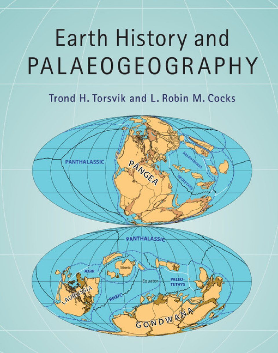
    This book is an example of what happens when you go down rabbit holes. I have been reading several books on the subject of palaeontology and geology lately, and I know that the face of the earth has shifted over the hundreds of millions of years of deep history covered in these books. But where were all the continents at different times? Many will have seen the iconic maps of the supercontinent Pangaea. But I want to know more. What happened in between? And before? As Nield tells in Supercontinent, Pangaea was only one of several such supercontinents in Earth’s history. But I want to know more still. Where exactly were the continents located? And how did they move? Several accessible books have provided snapshots of iconic moments, such as the formation of the Himalayas (Mike Searle’s Colliding Continents) or the disappearance of the Tethys ocean (Dorrik Stow’s Vanished Ocean). But I want to know more! This technical reference work contains lots of fantastic palaeogeographical maps that answered all my questions.

    Trond H. Torsvik and L. Robin M. Cocks, both established geologists, draw on a huge body of interdisciplinary knowledge for this book. This includes, amongst others, palaeomagnetism and polar reversals (see my recent review of The Spinning Magnet for an introduction), past volcanic eruptions, geophysics and tomography (a technique to visualise the inside of the planet), the rock record, and fossil distribution. Putting this all together allows them to reconstruct the face of the Earth over the last 540 million years. We know that plate tectonics was happening earlier in time as well, the geological story at the heart of the lyrical A Wilder Time was that we have evidence for plate tectonics as far back as approximately 2 billion years, and this book even mentions 3 billion years. But details just become too sketchy to make reliable planetary-scale reconstructions. So, as the authors make clear, this is by no means the definitive story but a work in progress. This book shows the current state of our knowledge, which will no doubt be further refined in the future.

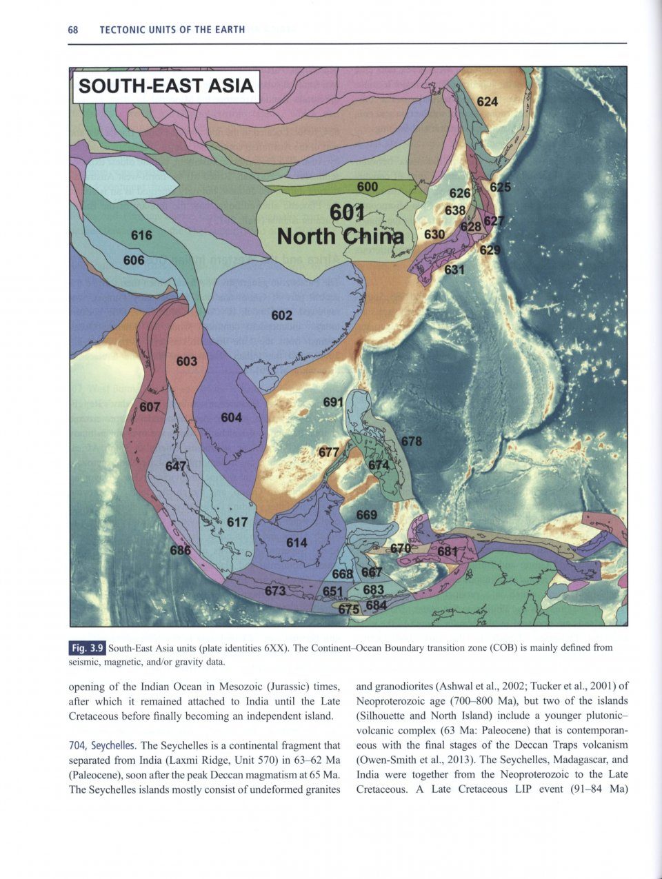
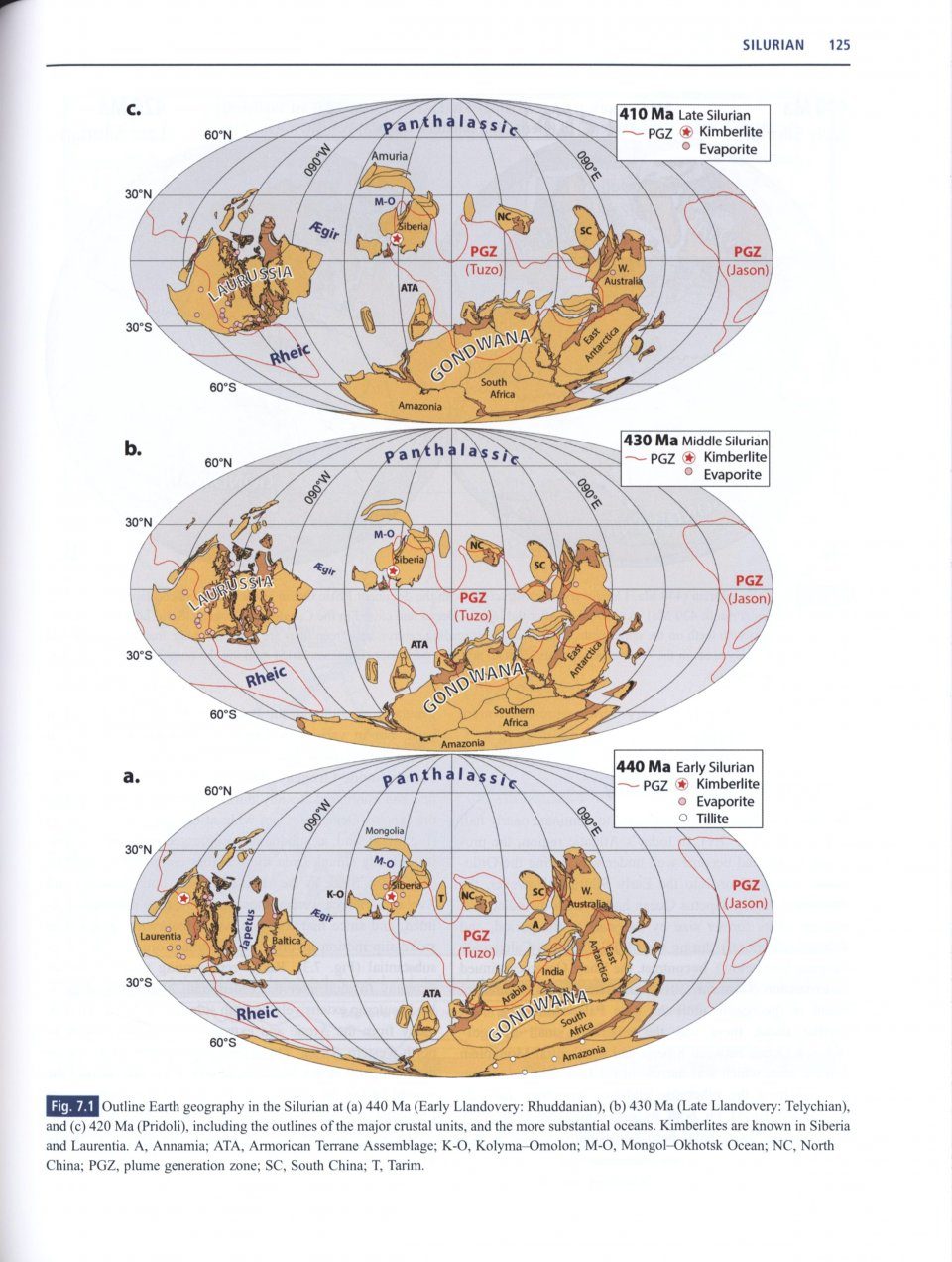
    After outlining their methodology and introducing, with maps, all 268 tectonic units that they have recognised as currently making up the surface of our planet (that’s a lot more you typically see on schematic maps) we get to the bulk of the book. This consists of eleven chapters that cover each geological period from the Cambrian (541-487 million years ago) to the Neogene and Quaternary (23 million years ago to today). Each chapter starts with several overview maps of the whole planet at various stages of each geological period which are already worth their weight in gold if this floats your boat. But that’s just the beginning.

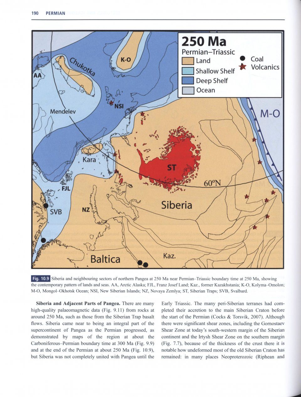
    A large number of maps and diagrams show different projections and perspectives, systematically going through each of the major continents as they existed back then. These maps show current continent outlines and estimated coastlines and deep and shallow seas back then, but also divisions between plates where the seabed was spreading apart or where plates were being subducted or colliding to form mountains chains. Symbols indicate approximate locations of major reefs, ice caps, lakes, areas of volcanic activity including large igneous provinces (the massive volcanic eruptions implicated in mass extinctions that we met in The Ends of the World), areas where coal was deposited, areas that dried up and left evaporites, faunal provinces that show the distribution of important fossil groups, as well as side-bars with approximate sea-level and climate conditions compared to today, and many other details. In the later chapters on geologically younger periods, when more details can be reliably reconstructed, many other diagrams and maps are shown, detailing the formation of mountain ranges such as the Himalayas, the appearance and disappearance of oceans, movements of the oceanic plates, etc. etc. The amount of information that is packed into these figures is breathtaking.

    The text, meanwhile, links together the different events depicted and provides further context and details. Some things cannot be shown on the maps, such as the location of certain minor plates. We know they were somewhere, but we often lack enough information to place them on a map in any meaningful way. The text not only covers the geological details but also contains a section describing the dominant flora and fauna and important developments in the evolution of life during the period in question.

    The book is not what you would call bedtime reading (though that did not stop me from doing so anyway) and is suffused with jargon. This comes from three sources. All geological periods are divided into shorter stages that have their own names, as shown on the official International Chronostratigraphic Chart that is printed on both endpapers. All 268 tectonic units have their own names that are introduced in detail in chapter 3. But on top of that is the terminology for geological processes and rock types. This is where my decision to study biology rather than geology comes back to bite me (I am looking at investing in some undergraduate geology textbooks because the subject continues to interest me). So if, like me, you can’t tell your ignimbrite from your gneiss, or don’t know the difference between volcanoclastic intercalations and diachronous migration, you might struggle with the text. Now, to fault the book for this would be completely missing the point. This is an advanced-level reference work, squarely aimed at an audience of geologists and palaeontologists with the relevant background knowledge – but it is good to know going in. Even so, with my limited knowledge of geological processes mostly gleaned from popular academic books, I was able to follow the grand narrative just fine. And what a fantastic story it tells!

    I cannot think of another book that takes such a clear, graphic approach as Earth History and Palaeogeography does. Not being familiar with the field, I am hesitant to claim this is a first, but it is obviously a very valuable compilation of the current state of our knowledge. For geologists and palaeontologists this is a mandatory reference work, but academically-minded book readers might also find this very interesting. I expect I will regularly be pulling it off the shelf to consult it while reading other books on palaeontology or geology.

    For those interested, there are supplementary online resources, including several programmes that allow you to make your own reconstructions, including graphics and maps like the ones shown in the book. I have not played around with this, but it is fantastic to see the authors willing to keep this project alive post-publication.
    10 of 10 found this helpful - Was this helpful to you? Yes No

Biography

Trond H. Torsvik is the Founding Director of the Centre for Earth Evolution and Dynamics (CEED), University of Oslo and Honorary Professor at Wits University, Johannesburg. He is a Member of the Norwegian Academy, and was awarded the prestigious Arthur Holmes Medal from the European Union of Geosciences in 2016 and the Leopold Von Buch Medal from the German Geological Society in 2015 for outstanding achievements in the geosciences, among various other awards and prizes. He has written over 200 publications in refereed journals and books.

L. Robin M. Cocks OBE TD is a Scientific Associate in the Department of Earth Sciences at the Natural History Museum, London, where he was formerly Keeper of Palaeontology. He has been President of the Geological Society of London, the Palaeontological Association, the Geologists' Association and the Palaeontographical Society. In 1995 he was awarded the Geological Society's Coke Medal, and in 2010 the Lapworth Medal by the Paleaontological Association, its highest honour.

By: Trond H Torsvik(Author), L Robin M Cocks(Author)
317 pages, 32 colour illustrations, 136 colour maps
NHBS
A unique, advanced-level reference work that provides a graphics-heavy overview of the Earth's continents through deep time.
Media reviews

" state-of-the-art summary of the distribution and history of the continents through geological time, splendidly illustrated. It is a major achievement of geological synthesis and deserves a place in the library of every Earth scientist and palaeontologist."
– Richard Fortey, FRS FRSL

"Torsvik and Cocks take on the Herculean pursuit of weaving together the palaeogeographic history of planet Earth in a single treatise. The authors take us step by step through the process of assembling palaeogeographic maps using palaeomagnetic, palaeontological, climatological and geological information. Following detailed introductory chapters on methods, descriptions of tectonic units and a review of the Precambrian, the book progresses through the Phanerozoic Eon with a period-by-period discussion of regional and global palaeogeography. In each chapter, the reader is presented with highly detailed palaeogeographic maps (in color) and a comprehensive evaluation of data used in those reconstructions. Torsvik and Cocks' combined decades of geodynamic and palaeontological expertise make this book indispensable to the geological community."
– Joseph Meert, University of Florida

"Since the advent of plate tectonics, some fifty years ago, geophysicists and palaeontologists have not always agreed on the ancient palaeogeography of the Earth and the position of its continents. This comprehensive and integrated narrative of the moving continents through deep time is the result of a paradigm-shifting collaboration between leaders in both fields and has moved the goal posts. This substantial book, beautifully illustrated and lucidly written, covers not only Earth geography through time but also the basic concepts, some new and innovative, and its relevance to other aspects of the evolution of our planet such as biodiversity and climate through the Phanerozoic. This monumental and superbly produced publication is essential reading for all students of Earth history and will be a lasting source of reference in the field, and beyond."
– David Harper, Durham University

"Torsvik and Cocks have jointly produced a spectacular textual narrative, laced with marvellous illustrations of the panthalassa framework surrounding the panoply of pangea forms in an effective panorama for the entire Phanerozoic"
– Rob Van der Voo, University of Michigan

"This reference book provides a beautifully illustrated history of our planet, Earth, over the past half billion years. Much of the tome provides detailed worldwide palaeogeographic maps and tectonic history, in chronological order from the Cambrian period, but it also contains a wealth of background and reference material. [...] The authors have generated software to make flat maps from a spherical Earth. They have made available supplementary online material, which permits anyone to make their own reconstructions at any time period since 540 million years ago. [...] [I]t is a wonderful reference companion to put any geological read into context."
– Maggie Deytrikh, Proceedings of the Open University Geological Society

"This incredibly ambitious publication covers more than a half billion years of tectonic movements and paleobiogeographic patterns [...] the events and patterns discussed do not occur in temporal or spatial isolation. Torsvik and Cocks did an admirable job of acknowledging these boundaries while writing the text in a format that is not confined by those limits. The authors have taken great care to provide extensive maps, including numbering and listing tectonic units in helpful ways [...] [The book] will provide the broad perspective that is foundational for other types of questions in biogeography. In addition to the unique strength of this volume in synthesizing immense amounts of data, the authors have much more information freely available online. The programs and data at their website open new innovative ways for teaching, the ability to explore research ideas, and a fun way to look at more maps."
– Dennis R. Ruez, Jr, The Quarterly Review of Biology

Current promotions
New and Forthcoming BooksNHBS Moth TrapBritish Wildlife MagazineBuyers Guides